Friday, July 22, 2005
Google Maps
 I noticed tonight that Google Maps has something new.... a "hybrid" option. When you click it....sometimes, (depending how close you're zoomed and whether or not there is a satellite view that close) you can see routes as well as whatever satellite image it shows. This works really great on those places you can zoom in the most.
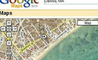
I tested this on Dennis, MA (among other places), scrolled the entire shoreline, because I wanted to see (all of the) Cape Cod, (shoreline, and all of that beautiful ocean. I'm happy even just seeing satellite views of beautiful ocean, silly huh?), and route 6 (and 28) and scenic 6A.
The Hybrid option shows the route on the satellite view, so you can clearly decipher the "road" among all those road-looking lines, to know for sure where it is, and how close to the water it really is (as well as those side streets that get you closer to a magical view).
What a great way to map a scenic drive!
(0) comments

![]()


